An image of the aerial photograph of Barlings Abbey WITHOUT the overlay may be viewed HERE
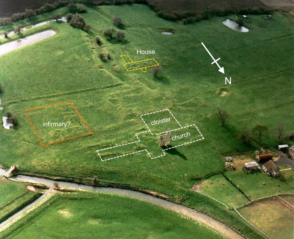
There have been no formal/recorded archaeological excavations at the site of Barlings abbey. The abbey precinct, now a scheduled pasture field, has just one fragment of standing masonry amidst a large area of earthworks which represent the lost ranges of monastic buildings; all ringed by a complex network of interlinked ponds, channels and leats. Within the area of earthworks, the site of the post-dissolution mansion can also be identified.
Formal study of Barlings began in June 1980 when Paul Everson, as part of a small survey team, carried out an earthwork survey of the site under the auspices of the Royal Commission on the Historical Monuments of England (RCHME). This survey was published in 1991 by Everson, Taylor and Dunn in Change and Continuity – Rural Settlement in North West Lincolnshire (pp.66-70). That work stimulated Everson and David Stocker to undertake a wider programme of study which culminated in the publication, in 2011, of a wide ranging report on Barlings Abbey and its wider landscape. (Everson, P. and Stocker, D., 2011, Custodians of Continuity? The Premonstratensian Abbey at Barlings and the Landscape of Ritual, Heckington.)

In the absence of excavated evidence, the RCHME survey gave the first opportunity to explore the scale of the site and to begin to understand the various buildings represented by the earthworks. Everson’s 1991 interpretation (keyed as letters on the plan) is as follows:
a – f: fish ponds, reservoirs and water channels; g: gatehouse to precinct; h: long, low stone wall; i: post-med track to ferry; j: surviving masonry fragment; k: chancel of abbey church; l: site of cloister; m: Infirmary?; n: post-med, L-shaped building (Wray’s mansion); o: garden water-feature; p: ditch and bank; q: barn?; r: well.

THE STANDING RUIN
The standing fragment of medieval masonry (j on the plan) can be identified as the north-west pier of the monastic conventual church together with the whole of the first bay of the nave arcade west of it and a fragment of the next bay west of that, plus a stub of walling going north from the crossing pier. The position of the masonry in the reconstructed plan of the abbey church can be seen in the illustration to the left
THE CHURCH
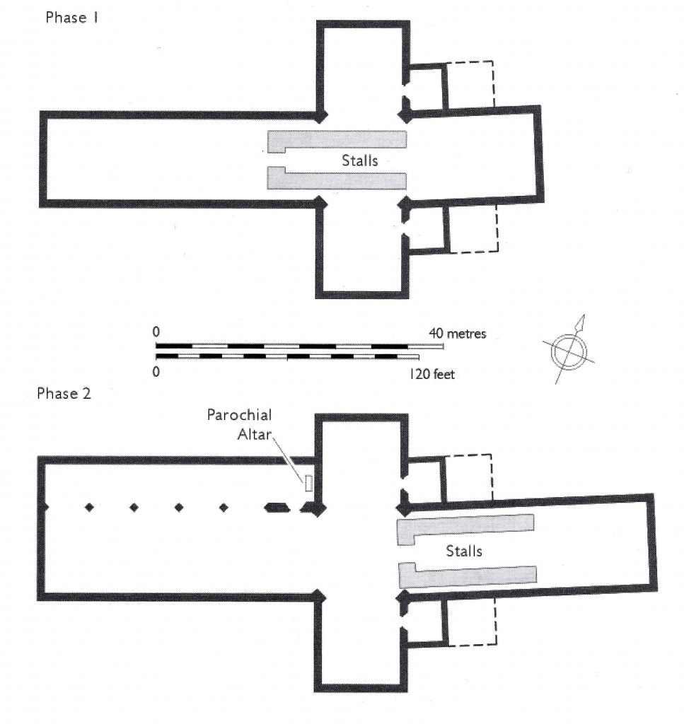
It is known that there was a major rebuilding campaign at the abbey in the mid-fourteenth century. Working from their analysis of the surviving fabric, Everson and Stocker have attempted to reconstruct the two phases of the abbey church – the late twelfth- and thirteenth-century (Phase 1) and the mid fourteenth-century (Phase 2).
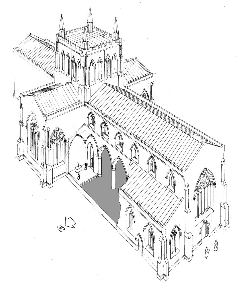
Using architectural details from eighteenth century drawings and engravings, and from drawings of the plethora of worked masonry around the site, Everson and Stocker were able to produce an artist’s impression of the church, including the arrangement of the parochial chapel (in cut-away).
Drawn by Tony Berry
CLOISTER & CHAPTER HOUSE
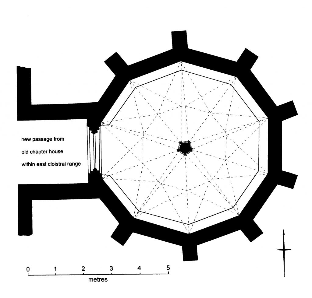
E & S believe that stone from the cloister and chapter house at Barlings was re-used in the late 16th C to rebuild St German’s church at Scothern. Architectural fragments recovered during refurbishment at Scothern in 2005 included a portion of a free-standing internal pier incorporating five projecting shafts. From this, they have postulated a decagonal chapter house at Barlings.
Whilst polygonal chapter houses are not rare, hexagonal or octagonal (as Cockersand) formats are more commonly seen.
OTHER PRECINCT BUILDINGS
Other notable buildings within the precinct include a potential gatehouse at the north-western corner of the precinct (g) and a substantial range of buildings to the east of the cloister, possibly the infirmary, incorporating a subsidiary cloister (m). To the south of the main cloister are the remains of the ‘abbot’s lodging’ (n), later adapted into a country house by Brandon and Wray. This is described in more detail in the ‘Post Dissolution’ section.
THE WIDER MONASTIC LANDSCAPE
Whilst Everson and Stocker’s work achieves a great deal in analysing what can be deduced of the form and structure of the abbey precinct and its buildings, it goes on to explore far, far more. They examine the granges and monastic manors in the home territory and analyse their buildings and their economic contribution to the monastic estate. Indeed, almost 80% of the monograph concentrates on these wider issues and the authors must be commended for their comprehensive study. This website, however, must limit itself to the descriptions and discussions of the abbey precinct and its buildings.
